ThEO

Climate protection and climate impacts

Stefan Erasmi and Arndt Piayda


BW Institute of Farm Economics
AK Institute of Climate-Smart Agriculture WO Institute of Forest Ecosystems

Does climate change affect agricultural use and forests? What are the effects of environmental and climate measures? Satellite data can be used to visualise spatial and temporal patterns of climate impacts and management measures.

Ongoing climate change and the associated occurrence of weather extremes such as droughts have direct implications for land use. Adaptation strategies must be implemented in both agriculture and forestry to maintain productivity. At the same time, extensive climate change mitigation measures are needed to mitigate the effects of climate change, especially in agriculture.

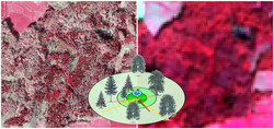
With remote sensing imagery available in a timely manner, management measures or climate impacts can be made visible, thus supporting research in the context of climate change and climate impacts.

Our research questions

  • Has agricultural use or management changed as a result of climate change (e.g., shifting/extending cropping or growing seasons)?
  • Have implemented environmental and climate change mitigation measures had a visible impact on land use (e.g., extensification of cultivation, increase in organic farming)?
  • How are certain climate-relevant uses spatially distributed (e.g. type and intensity of grassland use on organic soils as a proxy for greenhouse gas release, intercropping as a proxy for CO2 fixation)?

Projects

Copernicus lights green

Land consumption and intensification of use exert high pressure on grassland areas. Recording and assessing the condition and distribution of protected grassland and grassland worthy of protection requires a great deal of effort. In the future, satellite data should support official monitoring with area-wide services.

More
Copernicus lights green

Earth observation and artificial intelligence for monitoring of organic farming

By 2030, the share of organic farming in Germany aims to be expanded to 30% of agricultural land. Satellite data can help to show cultivated areas and differences in management practices between organic and conventional farming.

More
Earth observation and artificial intelligence for monitoring of organic farming

Monitoring groundwater levels in peatlands with radar data

Greenhouse gas emissions from organic soils are strongly influenced by the groundwater level. Deriving groundwater levels from remote sensing data could strongly improve the spatial and temporal resolution of greenhouse gas emission estimates.

More
Monitoring groundwater levels in peatlands with radar data

Monitoring of climate-impacting measures in crop and grassland management with satellite data

With 66.4 million tons of CO2 equivalents, agriculture was responsible for 9 % of greenhouse gas emissions in Germany in 2020. Adaptations in farm management can reduce these emissions. Area-wide data on such adaptation measures will be derived from high-resolution satellite data.

More
Monitoring of climate-impacting measures in crop and grassland management with satellite data

National Scale Tree Species Mapping for Germany

The project aims at generating wall-to-wall tree species distribution maps for the area of Germany by using National Forest Inventory data within remote sensing analysis.

More
National Scale Tree Species Mapping for Germany

National Scale Tree Species Mapping for Germany

The project aims at generating wall-to-wall tree species distribution maps for the area of Germany by using National Forest Inventory data within remote sensing analysis.

More
National Scale Tree Species Mapping for Germany

Remote sensing for improved climate reporting (KlimaFern)

Land use and agricultural measures are essential domains for achieving climate protection targets. Satellite data will be used to monitor agricultural land use over a wide area and to improve the data basis for reporting.

More
Remote sensing for improved climate reporting (KlimaFern)

Scroll to top