Project
Remote sensing for improved climate reporting (KlimaFern)
Remote sensing for improved climate reporting (KlimaFern)
Land use and agricultural measures are essential domains for achieving climate protection targets. Satellite data will be used to monitor agricultural land use over a wide area and to improve the data basis for reporting.
Background and Objective
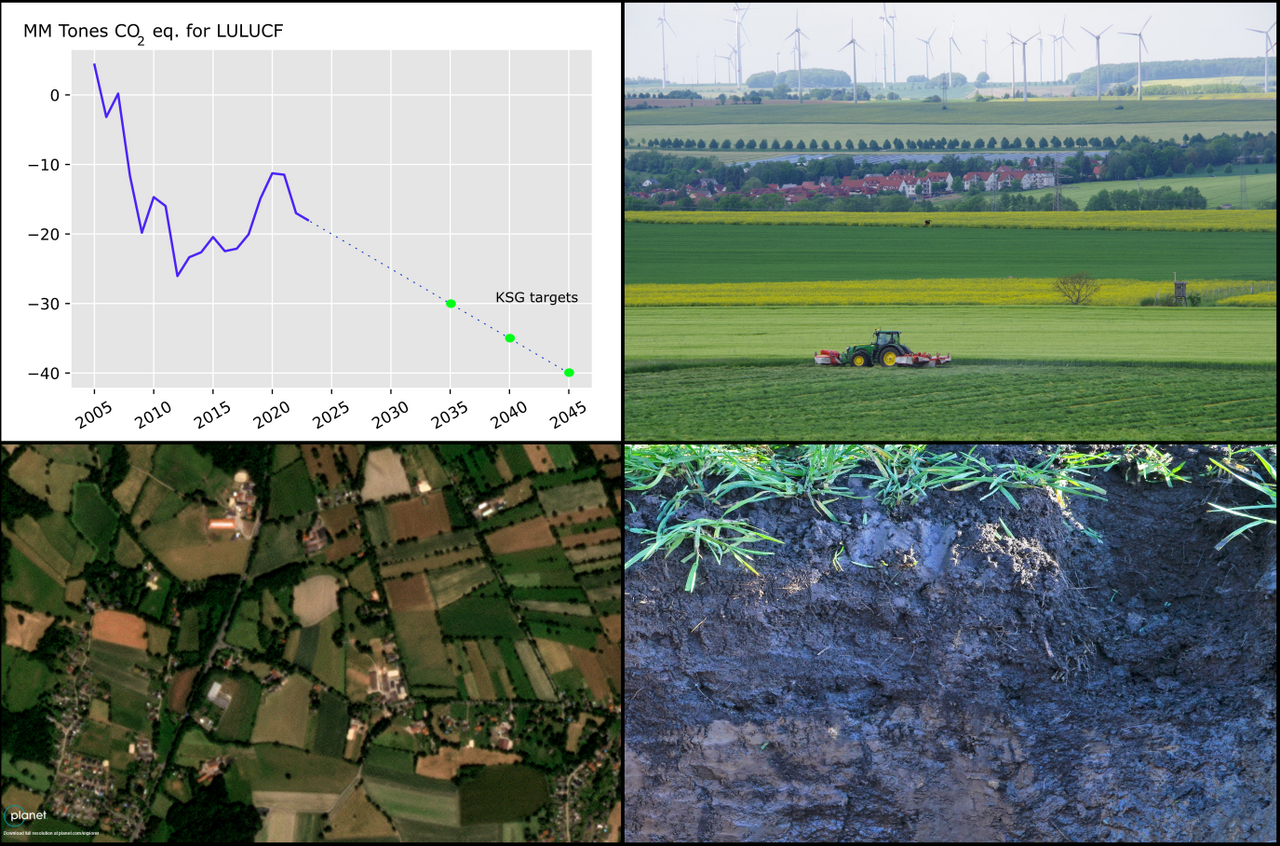
With the Climate Protection Law from August 2021, the German government tightened climate protection targets and anchored the goal of greenhouse gas neutrality by 2045. It requires an emission reduction of 65 percent by 2030 compared with 1990. The changes also affect the reduction targets in the land use, land use change, and forestry (LULUCF) sector. The BMEL has defined measures for the German government's climate protection program to help achieve the climate targets. An annual calculation of the emission situation, as a basis for greenhouse gas reporting and thus for monitoring target achievement, has so far been carried out for the LULUCF sector at the Thünen Institute based on land use data and empirical emission factors. However, the availability of land use data and especially "activity data", i.e. those land use measures that potentially contribute to carbon sequestration and thus to climate protection, is limited.
The prerequisite of carbon accounting for land use measures is the generation of a database that makes developments and the extent of actions visible and thus reportable to the climate change mitigation targets. Remote sensing is a suitable method to generate such data. Therefore, the need to improve the data basis for climate reporting in the LULUCF sector by including remote sensing data is already clearly addressed in the Federal Climate Protection Act (cf. §3a (3) sentence 4 B-KSG).
Concerning this, the overall objective of the KlimaFern project is to improve the data basis for the LULUCF sub-sector "agricultural land use" with the help of satellite data. This will be achieved by developing tools for the area-wide collection and evaluation of activity data based on high temporal and spatial resolution satellite data from different systems (optical and radar). In addition, the potential of remote sensing data for verifying reporting results will be investigated.
Approach
Our work in the KlimaFern project is based on satellite-based data collections that repeatedly and independently provide area-wide information on the condition, use, and changes in use over large areas. Based on the satellite data, indicators are calculated to describe the situation and land use (activity data, see above). Concerning climate protection and the reduction of emissions from agricultural land use, this means in particular the collection of indicators on humus preservation and grassland and peatland protection.
These indicators not only support the monitoring objectives for climate protection but are also suitable for characterizing other ecosystem services of agriculture (e.g. biodiversity, soil fertility, erosion control).
Using satellite data, the KlimaFern project addresses three subprojects (SP) for monitoring the climate mitigation measures and land use impacts in the LULUCF subsector "agricultural land use".
- SP1: Monitoring measures for humus sequestration in cropland (incl. hedgerows and field copses).
- SP2: Monitoring measures for the conservation of permanent grassland
- SP3: Monitoring soil carbon content in cropland
Data and Methods
The Sentinel satellites of the European earth observation program Copernicus (Sentinel-1 / -2) with their high spatial and temporal resolution are the data basis for this project. Using additional data from the Landsat missions, the study period can be extended to perform ex-post analyses for the reporting reference period (1990 / 2005). The project is supplemented with commercial and high-resolution data from the latest generation satellites (Planet, EnMap).
Reference information on land use and soil condition are available through cooperation with other projects at the Thünen Institute (BZE-LW, MuD HumusKlimaNetz, kliMAGS, CatchHedge).
Our Research Questions
Concerning the overall project goal, the following research questions will be investigated:
- Under which technical/infrastructural conditions (data availability, sensors, resolution of the data) and with which quality/accuracy can satellite data be used to generate area-wide status and activity data? Can this data improve the data situation (regarding the accuracy, resilience, and temporal intervals) for climate reporting?
- To what extent can satellite data be used to measure status and changes in soil carbon content in cropland as a parameter for validating and evaluating the effectiveness of climate protection measures on an area-wide basis?
- Can the integration of new high-resolution (commercial) satellite systems and new methodological approaches (e.g. AI) improve the accuracy in the spatiotemporal observation of measures and parameters?
Thünen-Contact

Involved Thünen-Partners
- Blickensdörfer, LukasBW Institute of Farm Economics
- Brög, TomBW Institute of Farm Economics
- Brög, TomBW Institute of Farm Economics
- Don, AxelAK Institute of Climate-Smart Agriculture
- Fuß, RolandAK Institute of Climate-Smart Agriculture
- Gocht, AlexanderBW Institute of Farm Economics
- Lobert, FelixBW Institute of Farm Economics
- Schwieder, MarcelBW Institute of Farm Economics
Funding Body
-
Federal Ministry of Agriculture, Food and Regional Identity (BMLEH)
(national, öffentlich)
Duration
10.2022 - 12.2025
More Information
Project status:
finished
Publications to the project
- 0
Brög T, Don A, Scholten T, Erasmi S (2026) Reducing bias in cropland soil organic carbon and clay predictions using Sentinel-2 composites and data balancing. Remote Sens Environ 333:115109, DOI:10.1016/j.rse.2025.115109
- 1
Lobert F, Schwieder M, Hostert P, Gocht A, Erasmi S (2025) Characterizing spatio-temporal patterns of winter cropland cover in Germany based on Landsat and Sentinel-2 time series. Int J Appl Earth Observ Geoinf 142:104728, DOI:10.1016/j.jag.2025.104728
- 2
Muro J, Blickensdörfer L, Don A, Köber A, Asam S, Schwieder M, Erasmi S (2025) Hedgerow mapping with high resolution satellite imagery to support policy initiatives at national level. Remote Sens Environ 328:114870, DOI:10.1016/j.rse.2025.114870
- 3
Axer M, Schlicht R, Blickensdörfer L (2025) Quantile regression for estimating Douglas-fir natural regeneration potential using the R package quaxnat: Advanced ecological modeling for the management of nature conservation and silviculture. Ecol Model 501:110968, DOI:10.1016/j.ecolmodel.2024.110968
- 4
Lobert F (2025) Remote sensing of cropland dynamics for climate-related agricultural monitoring in Germany. Berlin: Humboldt-Univ, xxi, 175 p, Berlin, Humboldt-Univ, Mathematisch-Naturwiss Fak, Diss, DOI:10.18452/34374
- 5
Brög T (2025) Remote sensing-based monitoring of cropland soil organic carbon. Tübingen: Eberhard Karls Univ, xxvii, 283 p, Tübingen, Univ, Mathematisch-Naturwiss Fak, Diss, 2025, DOI:10.15496/publikation-114189
- 6
Wang Y, Rammig A, Blickensdörfer L, Wang Y, Zhu XX, Buras A (2025) Species-specific responses of canopy greenness to the extreme droughts of 2018 and 2022 for four abundant tree species in Germany. Sci Total Environ 958:177938, DOI:10.1016/j.scitotenv.2024.177938
- 7
Lobert F, Schwieder M, Alsleben J, Brög T, Kowalski K, Okujeni A, Hostert P, Erasmi S (2025) Unveiling year-round cropland cover by soil-specific spectral unmixing of Landsat and Sentinel-2 time series. Remote Sens Environ 318:114594, DOI:10.1016/j.rse.2024.114594
- 8
Brög T, Don A, Wiesmeier M, Scholten T, Erasmi S (2024) Spatiotemporal monitoring of cropland soil organic carbon changes from space. Global Change Biol 30(12):e17608, DOI:10.1111/gcb.17608
- 9
Pham V-D, Tetteh GO, Thiel F, Erasmi S, Schwieder M, Frantz D, van der Linden S (2024) Temporally transferable crop mapping with temporal encoding and deep learning augmentations. Int J Appl Earth Observ Geoinf 129:103867, DOI:10.1016/j.jag.2024.103867
- 10
Brög T, Don A, Gocht A, Scholten T, Taghizadeh-Mehrjardi R, Erasmi S (2024) Using local ensemble models and Landsat bare soil composites for large-scale soil organic carbon maps in cropland. Geoderma 444:116850, DOI:10.1016/j.geoderma.2024.116850
- 11
Brög T, Blaschek M, Seitz S, Taghizadeh-Mehrjardi R, Zepp S, Scholten T (2023) Transferability of covariates to predict soil organic carbon in cropland soils. Remote Sensing 15(4):876, DOI:10.3390/rs15040876


