FAQ
Fire in the forest! What to do?
Michael Welling, Tanja Sanders, Anne Gnilke | 17.09.2025
The risk of forest fires exists every year; its severity varies depending on the weather and region. This was clearly evident in the summer of 2024 – despite record high temperatures, changeable weather with rainfall created warm, humid conditions, which led to a decline in forest fires. This year, the situation is quite different. EFFIS data shows that by August 2025, 5,400 hectares of forest had already been burned, a sad record.
It burns, it smokes or glows in the forest? Whether you see open fire, glowing or smouldering material, or simply smoke: Don’t hesitate to dial 112! You can reach the fire department and rescue service throughout Germany by dialling this number.
- State your name and describe the location as precisely as possible.
- Whenever possible, go to a rescue point (see below) to brief the emergency services from there on the damage area.
- Give your mobile number to the control centre and make yourself available for any further queries.
Do not put yourself in danger. Move away from the fire site and pay attention to the wind direction – a forest fire can spread quickly in windy and particularly dry conditions.
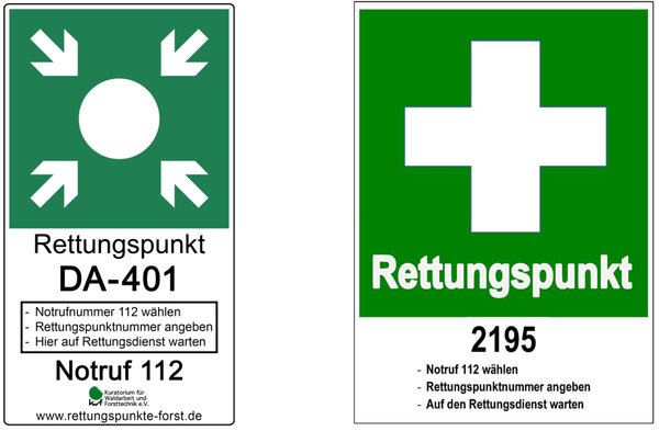
Forest rescue points are defined locations in the forest that use coordinates to describe meeting points. You can recognize rescue points by boards in the entrance area of forests. They make it easier to indicate your own location in case of accidents or fires. The rescue control centre can assign the number on the board, and medical staff or firefighters can find their way to the scene of the accident more quickly.
The rescue point files can be downloaded centrally at www.rettungspunkte-forst.de. With the free app "Hilfe im Wald" (for Android and iOS), the respective rescue points (now more than 50,000) can also be easily found via GPS using a smartphone.

Forest fires can have very different causes. Although the proportion of unexplained causes remains predominant, deliberate acts, negligence and human activity are nevertheless responsible for half of all forest fires and the majority of the area affected. These include:
- Arson.
- Cigarettes: from March 1 to October 31, smoking is prohibited in the forest. In the German states of Berlin, Brandenburg, Hesse, Mecklenburg-Western Pomerania, Rhineland-Palatinate, Saxony, Saxony-Anhalt and Thuringia, smoking and open fires are even banned all year round.
- Campfires and barbecues in the forest.
- Hot catalytic converters from cars or motorcycles parked in the forest or at the edge of the forest.
- Flying sparks from trains or fast rotating machine parts of forestry or agricultural machines.
- Spontaneous combustion (e.g. by old phosphorus ammunition or rotting hay).
- In rare cases a lightning strike can result in a fire.
Every year, the Federal Agency for Agriculture and Food (BLE) compiles data on forest fire frequency and forest fire area in Germany. According to this data, there have been an average of around 1000 forest fires per year over the past ten years. Most forest fires occur between April and July. Compared to other German states, Brandenburg is particularly susceptible to forest fires because of its rapidly drying, sandy soils and easily combustible pine forests.
In some years, damage caused by forest fires can easily run into the millions of euros, such as 2000, 2003, 2008, 2010, 2018, 2019, and 2020. The year 2022 was a year of extremes: more than 3,000 hectares burned, with damage exceeding 5 million euros.
In 2023, 1,059 fires destroyed around 1,240 hectares of forest (2022: 2,397 fires on 3,058 hectares) - the equivalent of around 1,771 football pitches. Almost 60 per cent of the damaged area was caused by fires in May. Around 77 per cent of the forest area (960 hectares) burned due to unexplained causes, followed by negligence with around 14 per cent.
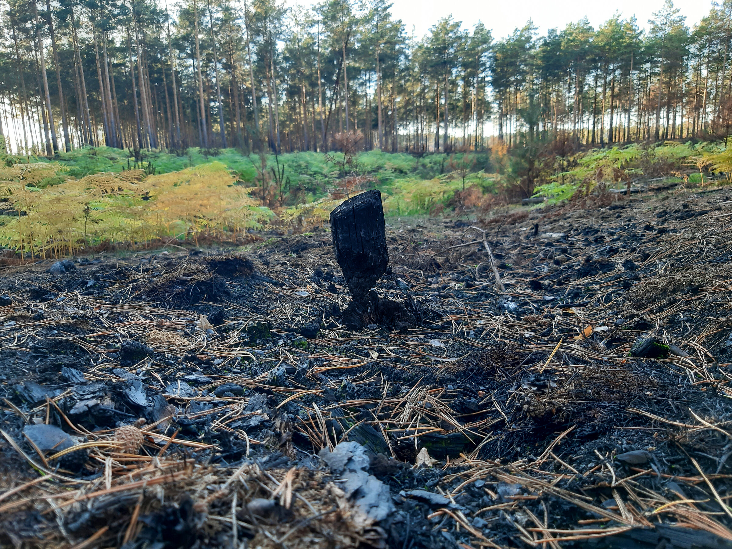
Forest fires usually start as ground fires. It can start when there is a lot of organic material such as leaves and dead wood on the ground. A ground fire is still fairly easy to fight, but can spread quickly through undergrowth and dry vegetation.
If a ground fire grows into a wildfire, it can spread to trunks - especially in conifer stands.
A wildfire can become a full fire, resulting in rapid spread of flames. The full fire includes ground vegetation, the trunk, and the crown of the tree. Dry needles cause the crowns to ignite in an extremely massive manner, contributing to accelerated and extensive spread.
In the case of a full fire, the firefighting operation is dangerous and difficult to bring under control. The fire intensity is so high that even wider paths can be jumped by the fire. It is difficult to prevent spread. A full fire can often only be successfully fought with support from the air.

The German Weather Service (Deutscher Wetterdienst; DWD) publishes the so-called forest fire hazard index (Waldbrandgefahrenindex) on its website on a daily basis. This shows on a map how high the forest fire danger is in the individual regions of Germany from a meteorological point of view.
The danger level is divided into five stages:
Level 1 very low danger
Level 2 low danger
Level 3 medium danger
Level 4 high dnger
Level 5 very high danger
On a smaller scale, individual German federal states also publish map-based overviews, for example Brandenburg.
As a further development of the forest fire hazard index, the Thünen Institute of Forest Ecosystems is creating a collection of data on forest fire history in the ErWiN joint project. The aim is to better understand forest fire causes and dynamics. In the project maps are being developed (e.g. below) that consider relevant forest structure parameters in addition to weather-based factors.


A few years ago, the Thünen Institute of Forest Ecosystems, together with the Humboldt University of Berlin, developed a system for early detection of forest fires. The core of the system is a hydrogen sensor. When organic material burns, the first thing that is produced is hydrogen. If the hydrogen concentration in the air exceeds a certain threshold, the sensor reports the possible fire to a control center. In this way, a smoldering fire can be detected before there is an open flame. Valuable time is saved.
In an interview in the magazine "Wissenschaft erleben, 2019/1", Jürgen Müller (Thünen Institute) and Michael Luthardt (State Competence Center for Forestry) talk about the novel forest fire sensor and the challenges following the 2018 forest fires (in German).
What impact did the three consecutive dry summers of 2018, 2019 and 2020 have on forest vitality - in addition to forest fires? How can forests adapt to climate change? More information here.


