ThEO
Biodiversity
Marcel Schwieder and Katja Oehmichen
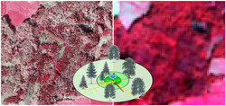
The type and intensity of use influences the ecosystem functions of agricultural landscapes and forests. Remote sensing data can be used to show the condition and stress of ecosystems over a wide area.

The biological diversity of a landscape section can be mapped against the background of the limited spatial resolution of freely available, area-wide satellite data on habitat diversity. Landscape and land use related indicators from remote sensing data can be used to describe the condition and stress of agricultural landscapes and forests.
Remote sensing-based approaches based on the data of the Copernicus program make it possible to observe and analyse these indicators nationwide in a fixed recurring temporal rhythm. This enables us to identify trends, on the basis of which we develop options for action and funding instruments for policy.
Our research questions
- How is biodiversity or landscape and land use diversity developing in open agricultural landscapes under the influence of land use and agricultural structure change?
- How are forest condition and structure developing in Germany under the influence of forest conversion, regeneration, afforestation and climate change?
 of an agricultural region in Brandenburg in false color representation. The plot shows radar-based (blue) and optical (green; Sentinel-2) indices for a meadow with two cuts.")