
The findings are summarized in the newly released Technical and Policy Brief No.1, which is based on the peer-reviewed study Freitas-Beyer et al. (2025) recently published in the Journal Remote Sensing.
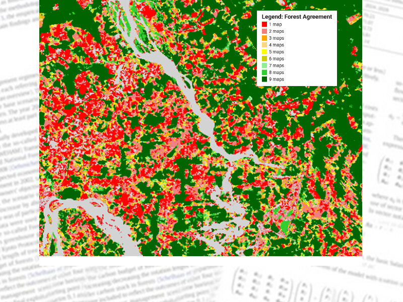
The assessment found that only eight datasets meet key spatial, temporal and definitional criteria for EUDR compliance checks, and only two datasets fully match the EUDR forest definition (canopy cover ≥10%, height ≥5 m, minimum mapping unit ≥0.5 ha). The study also highlights significant regional inconsistencies, risks of over- and underestimation, and challenges in distinguishing natural forests from plantations and agroforestry systems.
The policy brief offers practical guidance for operators and supply chain actors preparing due diligence statements, Competent supervisory authorities, and policy and decision-makers shaping data and monitoring frameworks.
Key recommendations include:
- avoiding reliance on a single map,
- combining multiple remote sensing datasets,
- integrating national or regional reference information,
- and promoting harmonization of forest definitions to improve comparability.
The GEOS-EUDR project is funded by the German Federal Ministry for Economic Cooperation and Development (BMZ).
Policy Brief:
Freitas Beyer J, Köthke M, Lippe M (2025) GEOS-EUDR : technical and policy brief no.1. Genève: Zenodo, 7 p
https://literatur.thuenen.de/digbib_extern/dn070199.pdfScientific Publication:
Freitas Beyer J, Köthke M, Lippe M (2025) Assessing the suitability of available global forest maps as reference tools for EUDR-compliant deforestation monitoring. Remote Sensing 17(17):3012, DOI:10.3390/rs17173012
https://literatur.thuenen.de/digbib_extern/dn070200.pdf