Project
Forest vitality and damage assessment using remote sensing and artifical intelligence
Product development for continuous, cross-scale productVitality and forest damage analysis by means of multisensoryRemote sensing data and artificial intelligence
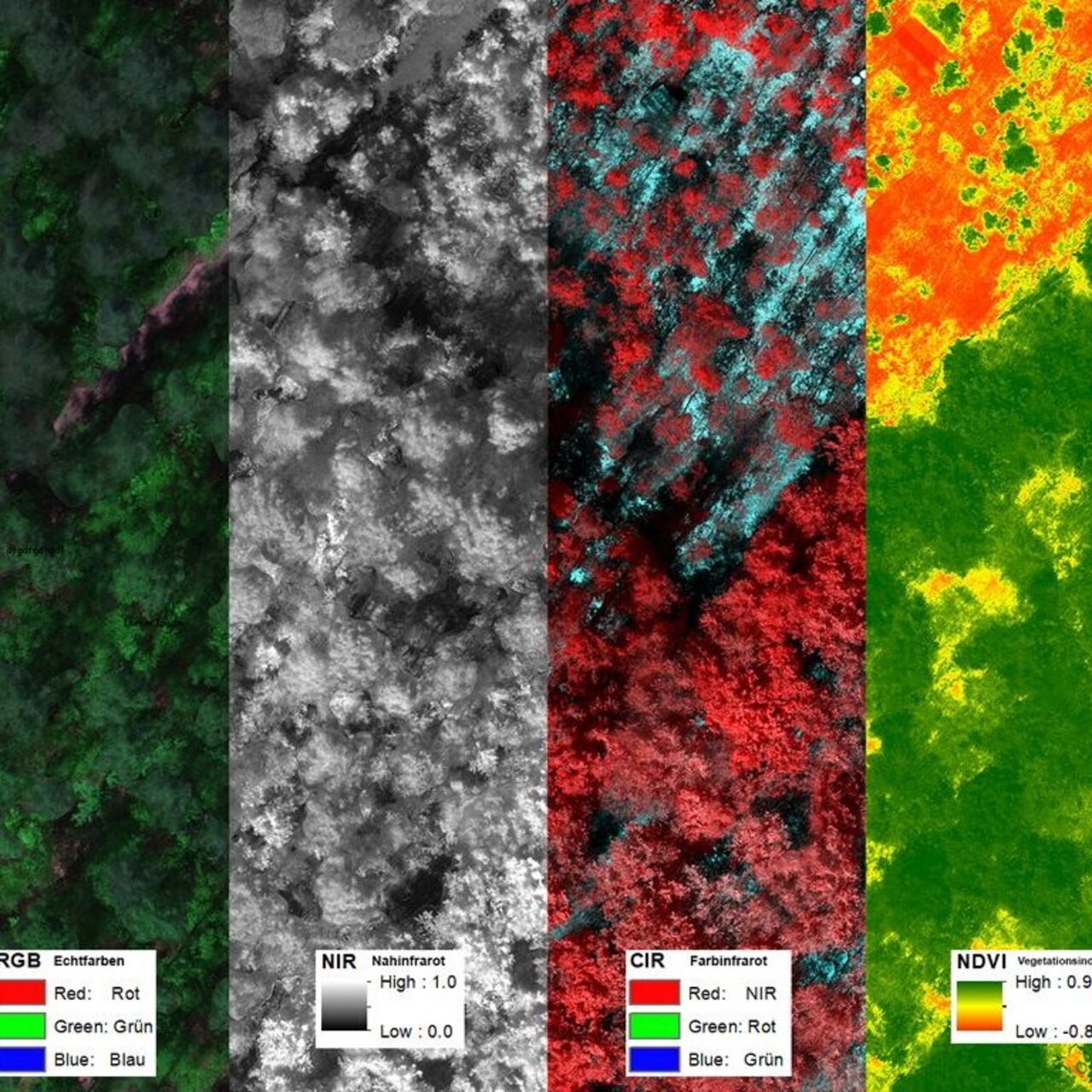
The investigation will be performed using satellite-based radar, optical, hyperspectral and thermal data, driven by cloud computing resources and the latest machine learning algorithms.
The different types of satellite data, in combination with in-situ measurements, will provide a range of information that will enable continuous cross-scale forest monitoring. In order to adapt the methods to the problem at hand, close cooperation with different forest stakeholders will be established.
Background and Objective
The aim of the project is the development of a user-related service for
cross-scale continuous vitality and forest damage analysis using
multisensory remote sensing data and artificial intelligence, which can be implemented by SaaS products
and customized services for the end user is supported. The products are used for the
Monitoring of various damaging events (storm, calamities, drought, fire) and
chains of damage have been developed in order to provide stakeholders from forestry and nature conservation with an improved
forest management.
Approach
In the 1st funding phase the project dealt with the potentials, provide by satellite data to support forestry process chains after a storm event. In the second phase of the mFund funding, the knowledge gained will be used to develop a product, which meets the requirements of public and private sector customers and private forest owners with regard to the information for vitality monitoring and detection
of different types of forest damage, such as storms, calamities, drought stress or fire.
Therefore, the development is to be carried out in close cooperation with private and state-owned forestry companies, the
different areas of forestry and nature conservation and are accompanied by these
be tested in practical application.
The focus is on the analysis of large amounts of satellite data in combination with
different data sources in order to identify in good time where action is needed, the
to optimise communication between the individual actors and ultimately
to support damage limitation and preventive measures.
The amount of available satellite data is increasing from year to year, at the same time
Data always cheaper. The number of commercial providers is increasing, parallel to this, for example
European Space Agency (esa) offers its data free of charge. The advantage of this data is
in the large-scale survey and in the short time intervals between individual
Recordings. Cloud services make it possible to transfer large amounts of data in the shortest time
process, merge and analyze. The development of algorithms of
artificial intelligence is, also due to the now available computing capacities, a very
living field.
The project consortium takes advantage of this, combines the aspects of data acquisition, -
processing and automated evaluation and applies this nationwide to the investigation of the
condition of the forests. Depending on the tree species and local boundary conditions
statements are made about how exposed this area is. Taking into account
of different data sources from the inventories and monitoring, an extensive
data basis used for the validation. The integration of historical data, satellite and
drone images and in-situ measurements should create a holistic picture that
enables decision-makers to carry out their work in a more targeted and efficient manner.
The use of mobile devices enables communication with personnel in the field and
conditions on site. This is how a new
Communication interface via which also the recording of the actual status and adjustment
with the expected conditions is made possible. The involvement of different actors from
the forestry and nature conservation sectors should ensure that all needs are covered.
Thünen-Contact
Funding Body
-
Bundesministerium für Verkehr und digitale Infrastruktur (BMVI)
(national, öffentlich)
Duration
7.2020 - 12.2022
More Information
Project status:
finished

Publications
- 0
Krause S, Sanders TGM (2023) Mapping tree water deficit with UAV thermal imaging and meteorological data. Remote Sens Earth Syst Sci 6(3-4):275-296, DOI:10.1007/s41976-023-00094-9
- 1
Krause S, Sanders TGM (2022) Drought stress detection of European beech with UAV Data Cubes [Präsentation]. In: European Space Agency’s 2022 Living Planet Symposium 23-27 May 2022, Bonn, Germany.
- 2
Krause S, Sanders TGM (2021) The application of UAV-based phenological data and machine learning models for drought stress detection in European beech [Online Präsentation]. In: 40th EARSeL Symposium 2021 : European remote sensing-new solutions for science and practice ; 07 - 10 June 2021 University of Warsaw, Faculty of geography and regional studies, Warsaw, Poland.