
Tropical dry forests play crucial roles both as an effective global carbon sink, and as the source of livelihood for a vast number of local communities.
However, mapping Miombo woodlands accurately into definable classes is a great challenge due to their sparse and heterogeneous nature and their alteration due to anthropogenic impacts.
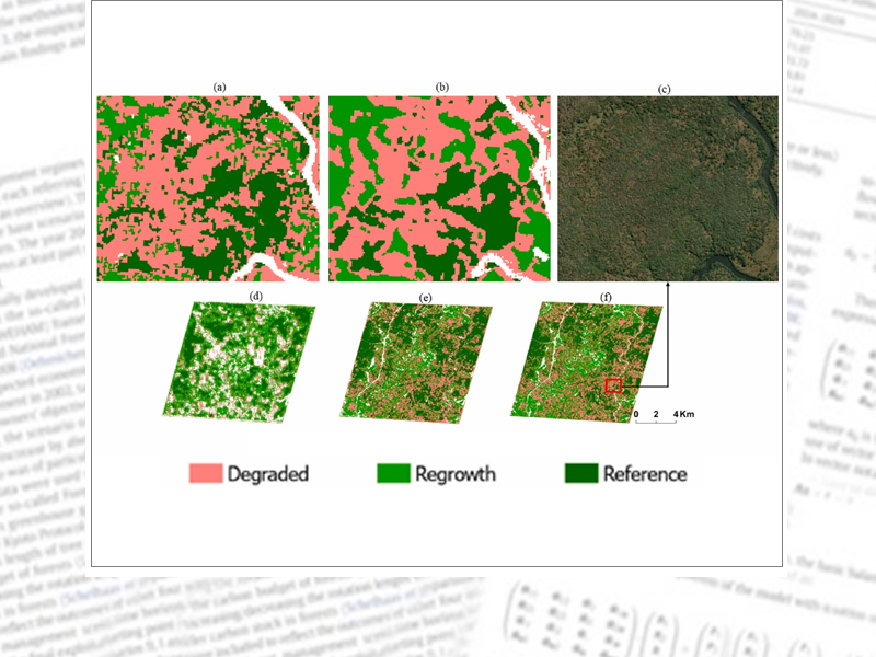
The study explored the use of Sentinel (S-1) and Sentinel-2 (S-2) seasonal and multi-seasonal images for (i) mapping Land Use Land Cover (LULC), and (ii) mapping three specific forest classes (reference, degraded and regrowth forests) within the Miombo woodlands of Zambia.
Models were trained, validated, and tested using ground validation data from the LaForeT project. Random Forest algorithm within Google Earth Engine was selected for the LULC classification while a U-Net convolutional neural network (CNN) was applied to classify the different types of forest.
The hierarchical approach employed demonstrated to be effective, providing more nuanced functional forest information. The approach holds great promise for mapping and monitoring programs of Miombo woodlands in Sub-Saharan Africa.
Kanja K, Zhang C, Lippe M, Atkinson PM (2025) Mapping tropical dry Miombo woodlands into functional forest classes using Sentinel-1 and Sentinel-2 imagery and machine learning. Remote Sens Appl Soc Environ 38:101615, DOI:10.1016/j.rsase.2025.101615
https://literatur.thuenen.de/digbib_extern/dn069940.pdfProjectsite
LaForeT | Landscape Forestry in the Tropics: REDD+ und Restoration