![[Translate to English:]](/media/_processed_/9/2/csm_Allgemein_Thueringen_Hainich_Mischwald_Bolte_2__19d9dab56a.jpg "[Translate to English:]")
![[Translate to English:]](/media/_processed_/d/2/csm_100_0001_0013_c05c63e7db.jpg "[Translate to English:]")
Project
Analysis of ghg emissions from forested peatlands
GHG emissions from forested peatlands during rewetting
Together with the Leibniz Centre for Agricultural Landscape Research (ZALF) ghg emissions are measured on two rewetted forested peatlands using automatic chamber systems.
Background and Objective
Drained peatlands emit large amounts of CO2. This is visible by peat loss and loss of terrain height, respectively. In natural „wet“ peatlands, dead plant material is not completely decomposed and forms peat. Previously by photosynthesis obtained carbon from the atmosphere is stored in peatlands. Thus, natural peatlands are a think for CO2. Although natural peatlands are a source for CH4, the ghg potential is lower compared to drained peatlands with high CO2 emissions. Over a long term, rewetting converts drained peatlands into natural peatlands. At our intensive sites in Buchenhorst and Johanngeorgenstadt, we investigate how ghg emissions (CO2, CH4 and N2O) change during this process. These measurements are planed long-lasting, since rewetting is a long-term process.
The two intensive sites are part of the German Peatland Monitoring Programme for Climate Protection – Forest (MoMoK-Wald).
Approach
Greenhouse gas emissions are analyzed with five automatic chamber systems per site. They consost of one transparant and on dark chamber each. They are placed successively on the ground to capture the released gases from the soil. The transparent chambers are used for the analysis of CO2 fluxes. Transparency of the chamber is important since CO2 fluxes are driven by photosynthesis, e.g. Dark chambers are used to analyse CH4 and N2O fluxes aswell as CO2 fluxes without photosynthesis. With this method, all three gases can be analyzed from one measurement plot. Gas samples from the chambers are transmitted to two gas analysers. They analyse the mixing ratio of the samples every second. So, emissions can be analyzed around the clock. Additionally, several other parameters which influence ghg emissions are recorded. These are radiation parameters, soil moisture, and soil temperature as well as all common meteorological parameters. Soil physical and chemical were analysed for both sites. The water level is recored using a level logger. The change of the terrain height is measured using metal rods anchored in the mineral soil. Changes the breast height diameter are recorded for selected trees. Both sites are equiped with remote data transmission.
Site Buchenhorst
- Mecklenburg-Vorpommern - Mecklenburgische Seenplatte
- Fen
- Alder
Site Johanngeorgenstadt (Großes Eisenstraßenmoor)
- Saxony - Erzgebirge
- Erzgebirge
- Peat bog (slope bog)
- Spruce
Our Research Questions
- How do ghg emissions change during rewetting (short- and long-term)
- How fast does the ecosystem shift from a ghg source to a sink
- How do tree stands affect rewetting
- How do tree stands react on rewetting
Thünen-Contact

Involved Thünen-Partners
Duration
1.2022 - 12.2026
More Information
Project status:
ongoing
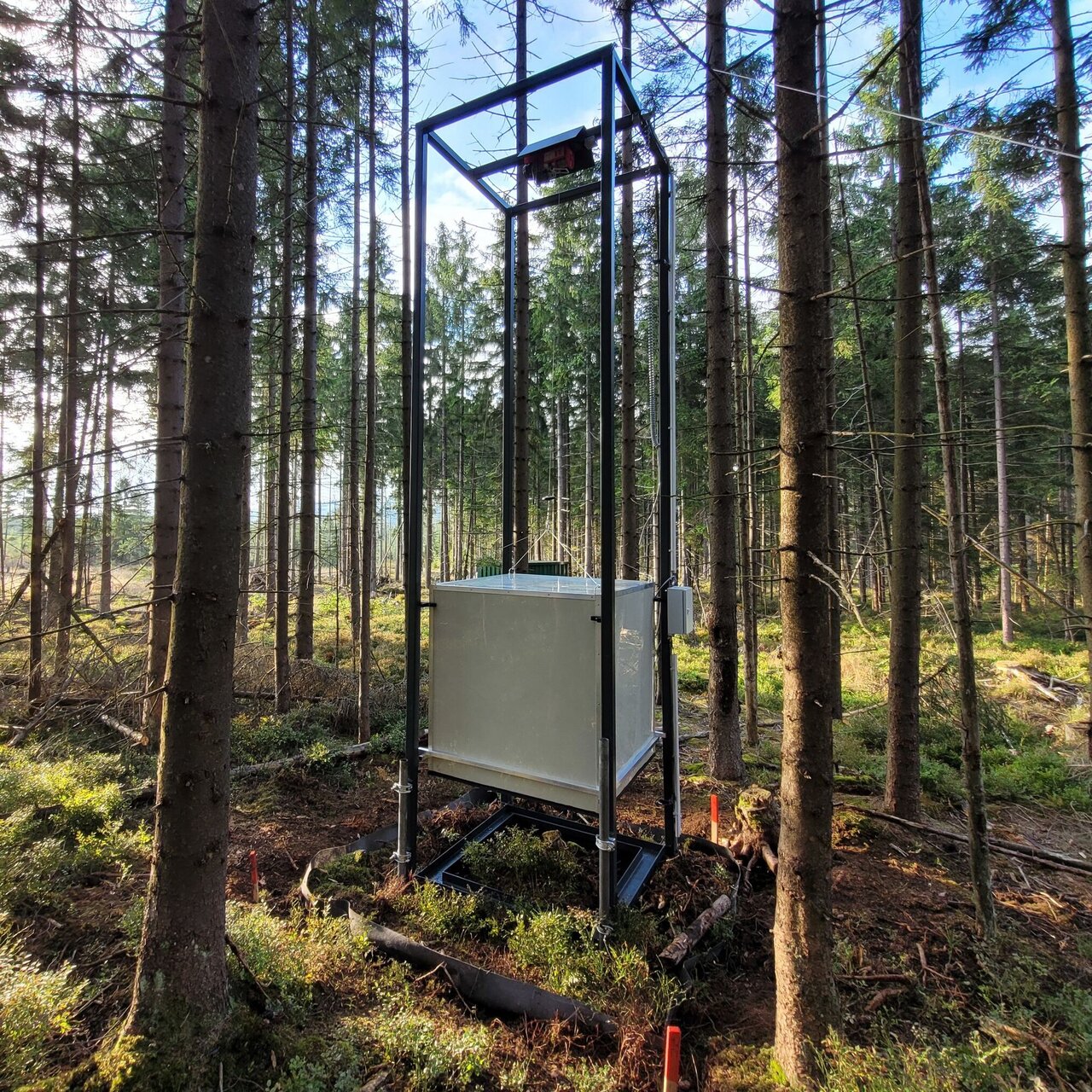
Construction and transport of five new measuring towers
In the summer of 2023, five new automatic chamber systems were assembled at ZALF e.V. in Müncheberg. A transparent and an opaque chamber hang in a 5 m high measuring tower. These can be automatically lowered to the peatland one after the other. All measurement data collected at the station as well as the data from the surveillance cameras are sent to Eberswalde via the mobile phone network. Control commands are sent to the measuring station in the other direction.
After construction, the measuring towers were transported individually on a car trailer to Johanngeorgenstadt. In order to place them in the intended locations, a horse provided by Sachsenforst was used, which pulled the 300 kg devices on a sledge the last 100 meters through the peatland and over former drainage ditches.


.")
Trenching procedure
In December 2022, the trenching method was also used at two measuring points at the second measuring location, Buchenhorst, Mecklenburg. The pictures show the digging work and the attachment of the fleece. During trenching, the measuring point is demarcated by a vertically inserted root-impermeable fleece. This prevents tree roots from penetrating. In comparison to areas without trenching, the proportion of tree root respiration can be determined.


 is inserted.")


