![[Translate to English:]](/media/_processed_/9/2/csm_Allgemein_Thueringen_Hainich_Mischwald_Bolte_2__19d9dab56a.jpg "[Translate to English:]")
![[Translate to English:]](/media/_processed_/d/2/csm_100_0001_0013_c05c63e7db.jpg "[Translate to English:]")
Project
Peatland monitoring - forest
![[Translate to English:]](/media/_processed_/0/b/csm_Hermsdorfer_Kreuz_CO_9ace8874d0.jpg)
Background and Objective
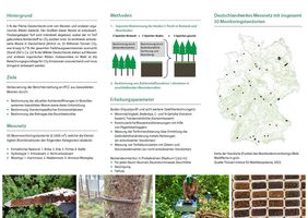
The Peatland Monitoring Programme for Climate Protection – Forest (MoMoK-Wald) aims to improve the reporting of greenhouse gas emissions of forested peatlands in a comparable and representative way. This nationwide basis can then also be used to derive measures for peatland soil protection.
Natural "wet" peatlands are of particular importance for climate protection, as they store large amounts of organic carbon. Drained peatlands, on the other side, emit this carbon into the atmosphere in the form of carbon dioxide (CO2). Despite a small area share of approx. 5% (=1,8 million hectares) drained peatlands (non-forested and forested) and other organic soils (e.g. Histic Gleysol) contribute to approx. 6,7% of German greenhouse gas emissions (as of 2021). These emissions are accounted for in the land use, land use change and forestry (LULUCF) sector. Currently, CO2 accounts for a large part (> 90 %) of these emissions. Thus, the preservation of carbon already stored in peatlands and other organic soils or a renewed sequestration plays an important role in climate protection. Around 15% of Germany’s peatlands are forested. This corresponds to about 2.4% of the German forest area. Despite this small area share, they represent a significant carbon stock and are a strong source of CO2 in the case of drainage. Currently, it is assumed that nearly all forested peatlands are drained. The Peatland Monitoring Programme intends to improve greenhouse gas reporting to the IPCC by recording changes in carbon stocks in peatlands and other organic soils and their controlling factors across Germany. In addition, potential measures are to be derived on this basis. To this end, a nationwide network will be established on peatland sites and other organic soils, with the openland peatlands covered by the Thünen Institute for Climate-Smart Agriculture and the forested peatlands covered by the Thünen Institute for Forest Ecosystems.
The overall objective is therefore to determine site-specific emission factors and to regionalise greenhouse gas fluxes in order to improve Germany-wide greenhouse gas reporting. For this purpose, i) the carbon stocks in soil and trees are recorded, and ii) carbon stock changes are recorded in continuous measurement intervals.
Especially, in the case of heavily degraded organic soils, the question arises as to how large the carbon sequestration from the remaining peat layer is in comparison to the carbon sequestration in the tree stand. Furthermore, based on the results it will be possible to derive site-specific recommendations for forest management.
Approach
50 monitoring sites, each with an area of 2500 m², are categorised according to the type of peatland (raised and transitional bog; fen), the hydrological condition (drained; non-drained) and the tree population. Only areas with a homogeneous (>80 %) share of spruce, pine, birch or alder tree species are selected.
In order to determine the current carbon stock in the soil, detailed soil surveys are carried out on a representative basis. In addition to the peatland thickness, important soil physical parameters (e.g. dry bulk density) and soil chemical parameters (e.g. C and N contents) are determined. The change in terrain elevation serves as the basis for calculating the change in soil carbon stocks. In the case of peatland subsidence, i.e. loss of terrain height, peat mineralisation occurs in addition to consolidation and shrinkage. During mineralisation, the carbon stored in the peat is released as CO2. Based on the losses of peat thickness, which are measured after defined time intervals (once a year), the CO2 release rate can be modelled. The change in terrain height is recorded with ten measurement poles per site, which are anchored in the mineral subsoil of the peatland. At non-drained sites, where peat surface oscillation and/or also carbon fixation through peat accumulation may occur, additional grids or volume elements are introduced into the topsoil to measure potential peat accumulation. The important control parameter peatland water level is recorded at each site with a water level data logger (hourly measurement interval).
To determine the carbon fixed in the stand and in the above-ground deadwood, as well as the vitality and vigour of the trees, additional stand surveys are carried out. For this purpose, the deadwood volume plus growth and vitality parameters of the individual trees (e.g. tree height diameter, total height) are recorded in a sampling circle of 12,62 m. In addition, four sampling circles (r = 5 m) are recorded to survey the regeneration. The procedure is based on the standardised protocols of the National Forest Soil Inventory (NFSI), so that the collected data of both programmes can be compared with each other.
In addition, a representative vegetation survey is carried out on 400 m² at each site. This serves the basic ecological characterisation of the site and is the basis for the long-term monitoring of the ecological condition and vegetation development. Thus, a contribution is made to the capturing and preservation of biodiversity. By recording functional traits of the existing vascular plants and peat mosses, it is tested, whether conclusions can be drawn about the conservation status and thus the carbon sequestration performance of the individual peatland sites from relatively easy-to-record biotic parameters.
In order to improve the understanding of the greenhouse gas dynamics, two areas will also be equipped with intensive measurement technology, on which a direct analysis of greenhouse gas emissions will be carried out using automated chamber technology ("Measurement of GHG emissions from forest peatlands"). The results of these gas measurements will be used to validate the results of the peatland soil monitoring by comparing the C- emission factors, determined based on the measurement parameters "water level" and "terrain elevation change", with those from directly measured emissions.
The results of each monitoring site are used for a combined modelling of carbon dynamics (soil and stock of trees) including control variables (e.g. peatland water levels, terrain elevation change, temperature, etc.). The consideration of regionalisation parameters (e.g. annual precipitation, annual average temperature, geomorphology) allows a regionally differentiated estimation of carbon dynamics in forested peatlands for IPCC reporting. Emission factors for different types of forested peatlands and their tree stocks are derived from the measured data and the modelling results. Up to now, these have only existed as estimated values. The peatland monitoring thus provides the long-term and area-wide emission data of organic soils under forest needed for the IPCC reporting.
Thünen-Contact

Involved Thünen-Partners
- Bielefeldt, JudithWO Institute of Forest Ecosystems
- Gabriel, MarvinWO Institute of Forest Ecosystems
- Kaufmann, AndreasWO Institute of Forest Ecosystems
- Matras, PaulWO Institute of Forest Ecosystems
- Oertel, CorneliusWO Institute of Forest Ecosystems
- Scherstjanoi, MarcWO Institute of Forest Ecosystems
- Seimert, MarcWO Institute of Forest Ecosystems
- Seimert, MarcWO Institute of Forest Ecosystems
- Seimert, MarcWO Institute of Forest Ecosystems
- Seiter-Amrhein, LenaWO Institute of Forest Ecosystems
Duration
1.2021 - 5.2025
Field manual for Monitoring of forested peatland soils published (November 2023)

A detailed documentation of the methods and work steps was published for the first time in German language in November 2023:
Methodenhandbuch für den Aufbau eines deutschlandweiten Moorbodenmonitorings für den Klimaschutz (MoMoK)- Teil 2: Wald von Marvin Gabriel, Julian Gärtner, Nora Pfaffner, Cornelius Oertel, Marc Seimert, Judith Bielefeldt, Vera Makowski, Nicole Wellbrock
First results

Laboratory work for MoMoK
The soil samples for MoMoK are analyzed at the laboratory at the Thünen Institute Eberswalde. Some of the work steps are documented in the pictures. The soil sample go in crucibles into the muffle furnace and are heated to up to 550°. To determine the loss on ignition in percent, the material is weighed before and after heating.


Picture gallery - peatland monitoring forest
![[Translate to English:] Partly shallowly inundated alder carr. The Postluch near Eberswalde in Brandenburg.](/media/institute/wo/Waldmonitoring/Bilder/BZE_Slides/projekt/MOMOK/Bildergalerie/1_MG.jpg "Click to zoom image")
![[Translate to English:] Spruce stand on drained peatland, which is not recognizable as such. Wildenkiel in Lower Saxony.](/media/institute/wo/Waldmonitoring/Bilder/BZE_Slides/projekt/MOMOK/Bildergalerie/2_CO.jpg "Click to zoom image")
![[Translate to English:] Peatland dominated by Molina caerulea with old moor birches (Betula pubescens). Die Grundlose in North-Rhine Westphalia.](/media/institute/wo/Waldmonitoring/Bilder/BZE_Slides/projekt/MOMOK/Bildergalerie/3_MG.jpg "Click to zoom image")
![[Translate to English:] Peatland with alders (Alnus glutinosa). Ellerwiese in Rheinhards-Forest in Hesse.](/media/institute/wo/Waldmonitoring/Bilder/BZE_Slides/projekt/MOMOK/Bildergalerie/4_CO.jpg "Click to zoom image")
![[Translate to English:] Spring fen in near-natural state with spruce stand. Spitziger Berg in the Thuringian Forest.](/media/institute/wo/Waldmonitoring/Bilder/BZE_Slides/projekt/MOMOK/Bildergalerie/5_CO.jpg "Click to zoom image")
![[Translate to English:] Peatmosses (Sphagnum palustre) at the ground of the forest next to beech (Fagus sylvatica) and alder (Alnus glutinosa) leaves](/media/institute/wo/Waldmonitoring/Bilder/BZE_Slides/projekt/MOMOK/Bildergalerie/6_CO.jpg "Click to zoom image")
![[Translate to English:] Measurement of the breast height diameter of an alder tree (Alnus Glutinosa) in a drained peatland, which already experienced peat subsidence. Kleiner Buxpfuhl in Brandenburg.](/media/institute/wo/Waldmonitoring/Bilder/BZE_Slides/projekt/MOMOK/Bildergalerie/7_NP.jpg "Click to zoom image")
![[Translate to English:] Dendrometer to measure the increase of the stem perimeter of a spruce (Picea abies). Großes Eisenstraßenmoor in the Ore Moutains in Saxony.](/media/institute/wo/Waldmonitoring/Bilder/BZE_Slides/projekt/MOMOK/Bildergalerie/8_CO.jpg "Click to zoom image")
![[Translate to English:] Peat soil profile of a drained peatland, which originally was treeless (peat horizons without wood). Kleiner Buxpfuhl in Brandenburg.](/media/institute/wo/Waldmonitoring/Bilder/BZE_Slides/projekt/MOMOK/Bildergalerie/9_NP.JPG "Click to zoom image")
![[Translate to English:] Peat soil profile of a drained peatland which originally was forested (wood and entire trees form part of the peat). Milchbachmoor in the Ore Mountains in Saxony.](/media/institute/wo/Waldmonitoring/Bilder/BZE_Slides/projekt/MOMOK/Bildergalerie/10_NP.JPG "Click to zoom image")
![[Translate to English:] Peat core taken with a Russian peat corer from a depth of 0-50 cm. Horizon of recently formed peat of Sphagnum mosses (right) over a relic earthification horizon (dark substrate in the middle) over older Sphagnum peat (light substrate in the left part) in a peatland after regaining its hydrological equilibrium. Schwarzes Moor in the Rhön Mountains, Bavaria.](/media/institute/wo/Waldmonitoring/Bilder/BZE_Slides/projekt/MOMOK/Bildergalerie/11_MG.jpg "Click to zoom image")
![[Translate to English:] Peat core taken with a Russian peat corer from a depth of 0-50 cm with a 15 cm layer of sand within sedge-peat. Pfauenfließ in the Basin of Biesenthal in Brandenburg.](/media/institute/wo/Waldmonitoring/Bilder/BZE_Slides/projekt/MOMOK/Bildergalerie/12_MG.jpg "Click to zoom image")
![[Translate to English:] 24 aluminium trays with air-dried peat samples for further processing in the lab. Thünen Institute for Forest Ecosystems in Eberswalde.24 aluminium trays with air-dried peat samples for further processing in the lab. Thünen Institute for Forest Ecosystems in Eberswalde.](/media/institute/wo/Waldmonitoring/Bilder/BZE_Slides/projekt/MOMOK/Bildergalerie/13_CO.jpg "Click to zoom image")
![[Translate to English:] Measuring grid with a dimension of 1 x 1 m on the on the surface of a not drained peatland with Carex acutiformis, for a future assessment of the peat quantity accumulating on top. The Postluch near Eberswalde in Brandenburg.](/media/institute/wo/Waldmonitoring/Bilder/BZE_Slides/projekt/MOMOK/Bildergalerie/14_NP.JPG "Click to zoom image")
![[Translate to English:] Set-up of a well to monitor the peatland water-table with data logger, which is configurated by a field computer. Peatland in Brandenburg.](/media/institute/wo/Waldmonitoring/Bilder/BZE_Slides/projekt/MOMOK/Bildergalerie/15_CO.jpg "Click to zoom image")
![[Translate to English:] Measuring of the emerging part of a pole to determine changes in the peat surface elevation, which in future should serve to assess peat subsidence. Stromtrassenmoor near Spechthausen in Brandenburg.](/media/institute/wo/Waldmonitoring/Bilder/BZE_Slides/projekt/MOMOK/Bildergalerie/16_NP.JPG "Click to zoom image")
![[Translate to English:] Partly shallowly inundated alder carr. The Postluch near Eberswalde in Brandenburg.](/media/_processed_/8/6/csm_1_MG_734d42acc2.jpg "Partly shallowly inundated alder carr. The Postluch near Eberswalde in Brandenburg.")
![[Translate to English:] Spruce stand on drained peatland, which is not recognizable as such. Wildenkiel in Lower Saxony.](/media/_processed_/a/4/csm_2_CO_1f2a828576.jpg "Spruce stand on drained peatland, which is not recognizable as such. Wildenkiel in Lower Saxony.")
![[Translate to English:] Peatland dominated by Molina caerulea with old moor birches (Betula pubescens). Die Grundlose in North-Rhine Westphalia.](/media/_processed_/4/b/csm_3_MG_a6b6fbfea2.jpg "Peatland dominated by Molina caerulea with old moor birches (Betula pubescens). Die Grundlose in North-Rhine Westphalia.")
![[Translate to English:] Peatland with alders (Alnus glutinosa). Ellerwiese in Rheinhards-Forest in Hesse.](/media/_processed_/4/9/csm_4_CO_bec1962296.jpg "Peatland with alders (Alnus glutinosa). Ellerwiese in Rheinhards-Forest in Hesse.")
![[Translate to English:] Spring fen in near-natural state with spruce stand. Spitziger Berg in the Thuringian Forest.](/media/_processed_/a/c/csm_5_CO_978d20f8b2.jpg "Spring fen in near-natural state with spruce stand. Spitziger Berg in the Thuringian Forest.")
![[Translate to English:] Peatmosses (Sphagnum palustre) at the ground of the forest next to beech (Fagus sylvatica) and alder (Alnus glutinosa) leaves](/media/_processed_/e/8/csm_6_CO_affb1adcd3.jpg "Peatmosses (Sphagnum palustre) at the ground of the forest next to beech (Fagus sylvatica) and alder (Alnus glutinosa) leaves")
![[Translate to English:] Measurement of the breast height diameter of an alder tree (Alnus Glutinosa) in a drained peatland, which already experienced peat subsidence. Kleiner Buxpfuhl in Brandenburg.](/media/_processed_/a/e/csm_7_NP_4751aa728b.jpg "Measurement of the breast height diameter of an alder tree (Alnus Glutinosa) in a drained peatland, which already experienced peat subsidence. Kleiner Buxpfuhl in Brandenburg.")
![[Translate to English:] Dendrometer to measure the increase of the stem perimeter of a spruce (Picea abies). Großes Eisenstraßenmoor in the Ore Moutains in Saxony.](/media/_processed_/3/e/csm_8_CO_96466a3707.jpg "Dendrometer to measure the increase of the stem perimeter of a spruce (Picea abies). Großes Eisenstraßenmoor in the Ore Moutains in Saxony.")
![[Translate to English:] Peat soil profile of a drained peatland, which originally was treeless (peat horizons without wood). Kleiner Buxpfuhl in Brandenburg.](/media/_processed_/b/b/csm_9_NP_219dfc3d0a.jpg "Peat soil profile of a drained peatland, which originally was treeless (peat horizons without wood). Kleiner Buxpfuhl in Brandenburg.")
![[Translate to English:] Peat soil profile of a drained peatland which originally was forested (wood and entire trees form part of the peat). Milchbachmoor in the Ore Mountains in Saxony.](/media/_processed_/6/5/csm_10_NP_b23aa7faca.jpg "Peat soil profile of a drained peatland which originally was forested (wood and entire trees form part of the peat). Milchbachmoor in the Ore Mountains in Saxony.")
![[Translate to English:] Peat core taken with a Russian peat corer from a depth of 0-50 cm. Horizon of recently formed peat of Sphagnum mosses (right) over a relic earthification horizon (dark substrate in the middle) over older Sphagnum peat (light substrate in the left part) in a peatland after regaining its hydrological equilibrium. Schwarzes Moor in the Rhön Mountains, Bavaria.](/media/_processed_/9/f/csm_11_MG_88341ce50a.jpg "Peat core taken with a Russian peat corer from a depth of 0-50 cm. Horizon of recently formed peat of Sphagnum mosses over a relic earthification horizon over older Sphagnum peat. Schwarzes Moor in the Rhön Mountains, Bavaria.")
![[Translate to English:] Peat core taken with a Russian peat corer from a depth of 0-50 cm with a 15 cm layer of sand within sedge-peat. Pfauenfließ in the Basin of Biesenthal in Brandenburg.](/media/_processed_/7/c/csm_12_MG_b1312b2e62.jpg "Peat core taken with a Russian peat corer from a depth of 0-50 cm with a 15 cm layer of sand within sedge-peat. Pfauenfließ in the Basin of Biesenthal in Brandenburg.")
![[Translate to English:] 24 aluminium trays with air-dried peat samples for further processing in the lab. Thünen Institute for Forest Ecosystems in Eberswalde.24 aluminium trays with air-dried peat samples for further processing in the lab. Thünen Institute for Forest Ecosystems in Eberswalde.](/media/_processed_/9/c/csm_13_CO_5b18f72264.jpg "24 aluminium trays with air-dried peat samples for further processing in the lab. Thünen Institute for Forest Ecosystems in Eberswalde.")
![[Translate to English:] Measuring grid with a dimension of 1 x 1 m on the on the surface of a not drained peatland with Carex acutiformis, for a future assessment of the peat quantity accumulating on top. The Postluch near Eberswalde in Brandenburg.](/media/_processed_/5/3/csm_14_NP_e89f55bd20.jpg "Measuring grid with a dimension of 1 x 1 m on the on the surface of a not drained peatland with Carex acutiformis, for a future assessment of the peat quantity accumulating on top. The Postluch near Eberswalde in Brandenburg.")
![[Translate to English:] Set-up of a well to monitor the peatland water-table with data logger, which is configurated by a field computer. Peatland in Brandenburg.](/media/_processed_/7/e/csm_15_CO_24eddf9662.jpg "Set-up of a well to monitor the peatland water-table with data logger, which is configurated by a field computer. Peatland in Brandenburg.")