![[Translate to English:]](/media/_processed_/9/2/csm_Allgemein_Thueringen_Hainich_Mischwald_Bolte_2__19d9dab56a.jpg "[Translate to English:]")
![[Translate to English:]](/media/_processed_/d/2/csm_100_0001_0013_c05c63e7db.jpg "[Translate to English:]")
Project
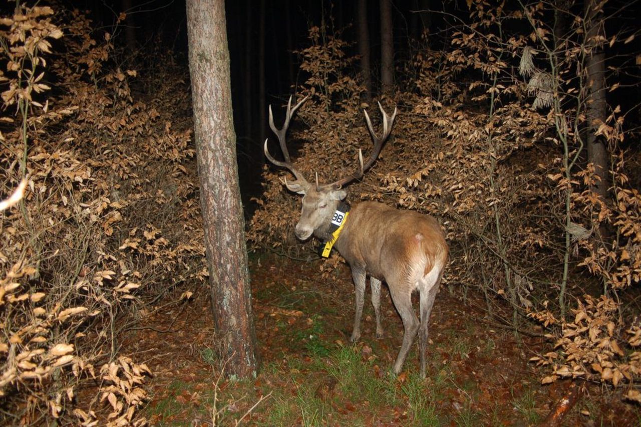
Studies of biorythms and habitat exploitation of red deer
In the last decades in many regions of Germany the hunting pressure on the deer continuously was increased for the forest conversion. On the other hand Intensive hunting and extended hunting seasons lead to a continuous use of sapling stage and to increase of game damage. It is therefore urgently necessary to see the habitat structure, the habitat improvement and the practice of hunting as an important unit and to develop new management strategies.
Background and Objective
With this goal carried out studies in the Thünen-Institute for Forest Ecosystems on the biorhythm of the red deer in different habitats since the early 2000s.
The investigations are carried out using GPS GSM satellite telemetry collar transmitter by the company VECTRONIC GmbH. There are determined the location data in a given time interval and sent via SMS. A collar transmitter provides in depending of the receiving quality and the signal frequency two to three years records. Thereby habitat exploitation and the activities of animals can be continuously observed without disturbance. In specific studies on the effect of various disturbances carried out the detection of the location data in a frequency of 15 to 30 minutes.
Target Group
Approach
Immobilization and marking, cartographic processing, editing by GIS analysis
Thünen-Contact
Involved Thünen-Partners
Duration
Permanent task 4.2002
More Information
Project status:
ongoing
Publications
- 0
Neumann M (2024) Wildbiologie : Im Zeichen der Krone. Jäger(2):30-35
- 1
Neumann M (2023) Alte Tiere. Jäger(12):60-64
- 2
Neumann M (2022) Wildbewirtschaftung : interessante Nachlese zum Rotwild-Telemetrieprojekt im Thüringer Wald. OÖ Jäger 49(177):16-18
- 3
Neumann M (2022) Wildbewirtschaftung : interessante Nachlese zum Rotwildtelemetrieprojekt im Thüringer Wald. Thüringer Jäger(11):11-13
- 4
Neumann M, Tandler M (2021) Was uns besendertes Rotwild verrät: Die Intervalljagd. Jägerin(4):34-36
- 5
Neumann M, Tandler M (2021) Wildruhezone und ihre Bedeutung für das Rotwildverhalten. Jägerin(1):16-20
- 6
Tottewitz F, Neumann M (2014) Relaxtes Rotwild : Ruhezonen und Intervalljagd. Wild Hund 117(3):14-19
- 7
Tottewitz F, Neumann M (2013) Rothirsche als Bioindikatoren. Nationalpark Info 22:6-7
- 8
Tottewitz F, Neumann M (2012) Was die Darß-Hirsche uns erzählen: Erstaunliche Ergebnisse offenbart : Untersuchungen zur Lebensraumnutzung des Rotwildes auf der Halbinsel Darß/Zingst im Nationalpark Vorpommersche Boddenlandschaft durch GPS-Satelliten-Telemetrie. Wald & Wild(8):1-4
- 9
Tottewitz F, Neumann M (2011) Raumnutzung Rotwild : Konflikte im Wohnzimmer. Pirsch(16):23-27
- 10
Tottewitz F, Neumann M (2011) Ruhestörer überführt : Beunruhigung von Rotwild. Unsere Jagd 61(6):10-15
- 11
Tottewitz F, Neumann M (2010) Untersuchungen zur Lebensraumnutzung des Rotwildes (Cervus elaphus L.) auf der Halbinsel Darß/Zingst im Nationalpark Vorpommersche Boddenlandschaft durch GPS-Satelliten-Telemetrie. Beitr Jagd Wildforsch 35:15-31
- 12
Neumann M, Tottewitz F (2010) Wildökologische Lebensraumbewertung auf dem Darß/Zingst. Beitr Jagd Wildforsch 35:33-42
- 13
Tottewitz F, Neumann M, Sparing H (2008) Hirsche, Halsbänder und Handys : wo und wie lebt Rotwild? ; Satellitentelemetrie beim Rotwild. Wild Hund Exkl 31:28-35
- 14
Neumann M, Tottewitz F, Sparing H, Gleich E (2007) Lebensraumgrößen von Rotwild im Thüringer Wald und im nordostdeutschen Tiefland - Ergebnisse von Satellitentelemetriestudien. Artenschutzrep 21:71-77
- 15
Neumann M, Tottewitz F, Sparing H, Gleich E (2007) Lebensraumnutzung von Rotwild im Thüringer Wald und im nordostdeutschen Tiefland - Ergebnisse von Satellitentelemetriestudien. Beitr Jagd Wildforsch 32:143-156
- 16
Neumann M, Tottewitz F, Sparing H, Gleich E (2006) Untersuchungen zur Lebenraumnutzung des Rotwildes (Cervus elephus L.) im Thüringer Wald durch GPS-Satelliten-Telemetrie. Beitr Jagd Wildforsch 31:151-158
- 17
Tottewitz F, Fischer T, Klein M (2005) Mit GPS das Rotwild im Visier : telemetrische Untersuchungen zu Lebensraumansprüchen des Rotwildes im Thüringer Wald. Unsere Jagd 55(2):36-37
- 18
Tottewitz F (2004) Telemetrische Untersuchungen zu Lebensraumansprüchen des Rotwildes im Thüringer Wald. In: Biotopverbund im Thüringer Wald : Tagungsband 2004 ; Tagungsreihe Naturschutz im Naturpark Thüringer Wald und im Biosphärenreservat Vesser. Schmiedefeld: Verwaltung Biosphärenreservat Vessertal, pp 47-53
- 19
Tottewitz F, Fischer T, Klein M (2003) Telemetrieprojekt erfolgreich angelaufen. Unsere Jagd 53(4):30